
Most Organizations See Their Own Work. Very Few Can See the Full Landscape.
Houston's nonprofits are doing powerful work inside a landscape most of them have never fully seen. A single neighborhood can sit inside a dozen overlapping jurisdictions, each with different leadership, different funding, and different accountability.
That is the fault-line of civic fragmentation, and it quietly shapes what every mission-driven organization can access, build, and sustain.
Invisibility has a cost. We created Bird's Eye Impact to name it — and fix it.
That is the work of Civic Landscaping.
Why your organization needs a
Bird's Eye View.
Bird's Eye Impact practices Civic Landscaping: the work of showing an organization where it resides inside civic districts, collaborative opportunities, and competitive programs — so it can build relationships and tap into the resources, public funding, and community connections that are already in its landscape.
We are defining this category because no mission-driven organization should have to navigate a civically fragmented landscape without a map.
Civic Landscaping has immediate ROI.
Stronger Partnerships
Build meaningful connections with aligned organizations and anchor institutions.
Better Alignment
Connect your mission directly to civic priorities and elected officials' agendas.
Expanded Funding
Discover new funding streams through strategic positioning and civic engagement.
Clearer Storytelling
Communicate your impact with context that resonates with funders and partners.
Strategic Decisions
Operate with confidence instead of guesswork, grounded in systems awareness
Our Deliverable: The Bird's Eye Atlas
The Bird's Eye Atlas answers questions your organization can't afford to leave unanswered.
- Where do we sit? (Positioning) Your Atlas maps exactly how your mission, geography, and service model intersect with civic boundaries, school districts, management districts, and public systems — so your leadership knows precisely where you reside in the civic landscape.
- What surrounds us? (Context) Your Atlas identifies the full ecosystem around you: collaborators, competitive programs, referral partners, and aligned institutions — making visible what your team has never had time to map on its own.
- Where is the opportunity? (Strategy) Your Atlas surfaces the strategic leverage points — funding pathways, civic relationships, and partnership opportunities — so you can move from navigating blind to acting with confidence.
The Bird's Eye Atlas is the tangible result of Civic Landscaping.
It is a physical and digital deliverable your leaders, staff, and stakeholders can use to navigate your community with clarity and confidence.
The Atlas is easily accessible, shareable, updatable, and most importantly, designed to be a tool that is easily and consistently used.
The Atlas is built from three Views:
The Ground View:
A narrative overview of your organization — your mission, programs, people, and structure — placed inside the fixed civic reality surrounding your work. This includes the elected offices, public jurisdictions, and governmental boundaries that shape access to resources and representation.
The Bird's Eye Interactive Map is first developed here, showing exactly where your organization resides within the civic office districts that govern your geography.
The Ecosystem View:
A full mapping of the landscape surrounding your organization — the active layer of relationships, resources, and programs that exist alongside your work.
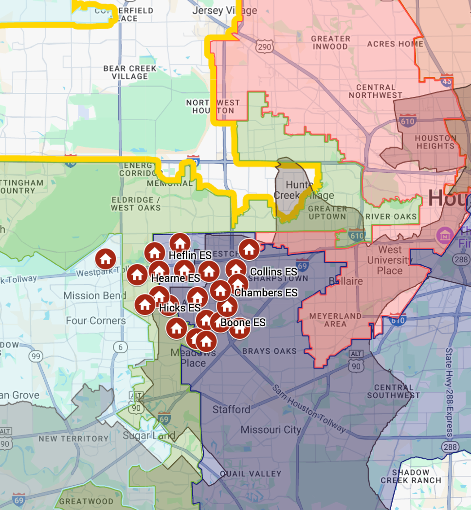
The Bird's Eye Interactive Map evolves here, adding three layers to the Ground View: Public Supports, Collaborative Opportunities, and Competitive Awareness. Together they reveal the fault-lines of civic fragmentation — the gaps, overlaps, and disconnections most organizations navigate without ever fully seeing.
The Guide View:
Actionable direction and tools drawn from everything the Atlas has surfaced —
Strategic Recommendations specific to your organization, in your landscape, at this moment; the fully activated Bird's Eye Interactive Map as both an internal strategy tool and an external storytelling asset; and a Stakeholder Presentation Suite including a digital slide deck, audio overview, and video explainer.
Together, these three views answer the questions every mission-driven organization needs answered.
3-Layer Context Map
We reveal the full ecosystem around your organization; visualized in civic, collaborative, and competitive layers.
The Ground Truth
We translate complexity into clarity with actionable intelligence and partnership pathways.
Strategic Recommenations
We identify funding pathways and strategic partnerships organizations rarely uncover alone.
Are you ready to unlock the opportunity in your community?
The 3-Layer Context Map Framework
Civic Landscaping is delivered through our 3-Layer Context Map, a framework that makes the invisible visible by showing exactly where your organization sits within the civic, collaborative, and competitive landscape.
The 3-Layer Context Map makes that landscape visible by bringing together the three layers every organization operates within: Civic, Collaborative, and Competitive Awareness.
The Bird's Eye Interactive Map
Most organizations see their own work clearly.
What they rarely see is the full landscape surrounding it — the civic systems that shape access and funding, the organizations doing complementary work nearby, and the competitive environment that defines their position in the ecosystem.
The Bird's Eye Interactive Map makes that landscape visible. View the Map.
It is the geographic and relational foundation of every Bird's Eye Atlas — and it grows with the work.
Every Bird's Eye Atlas includes two things that work together: an interactive, visual map, and a written narrative.
Together, they give your leadership something neither can provide alone: a complete picture that is both immediately visible and deeply understood.
Interactive, visual map that places your organization inside the civic, collaborative, and competitive landscape of your community.
You can zoom, filter, share, and explore it. It is updatable, easily shareable, and totally customized to your organization's landscape, making it a tool your team will return to.
Written narrative that explains what the map reveals — the context behind the boundaries, the significance of what surrounds you, and the patterns that data alone cannot communicate. This is where insight lives.
The map shows you the landscape. The narrative tells you what it means.
The written narrative is woven through all three views of the Atlas.
In the Ground View, it provides an organizational overview — your mission, programs, people, and structure placed inside the civic districts and systems that govern your geography.
In the Ecosystem View, it explains what the expanded landscape means for your work — the Public Supports available to you, the Collaborative Opportunities worth pursuing, and the Competitive Awareness your positioning requires.
In the
Guide View, it becomes the foundation for your Strategic Recommendations and is delivered as a full Stakeholder Presentation Suite — in copy, digital, audio, and video formats — so your leadership can communicate what the Atlas has revealed to funders, board members, and community partners.
What does a Bird's Eye Interactive Map Reveal?
Civic Systems
This layer reveals the power structures and public assets that determine access, voice, funding, and opportunity, and exposes why so many organizations struggle to access them.
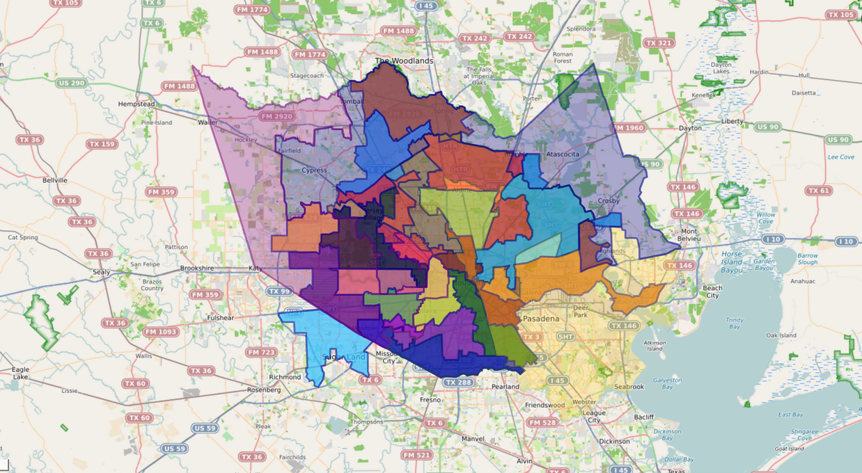
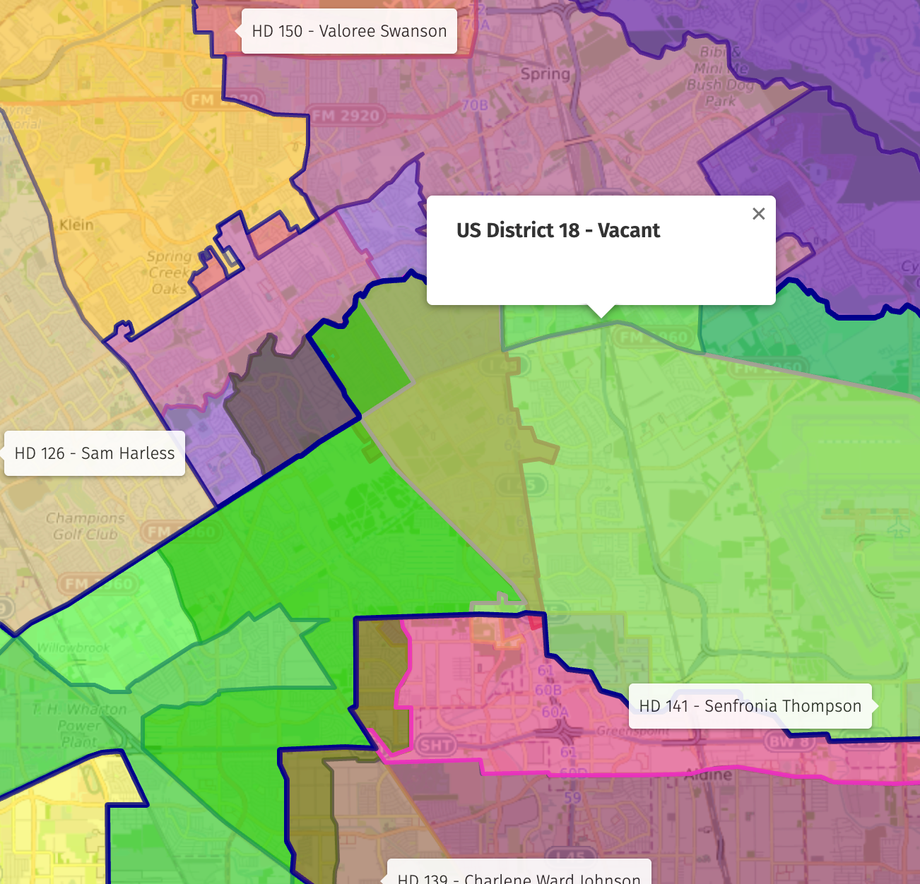
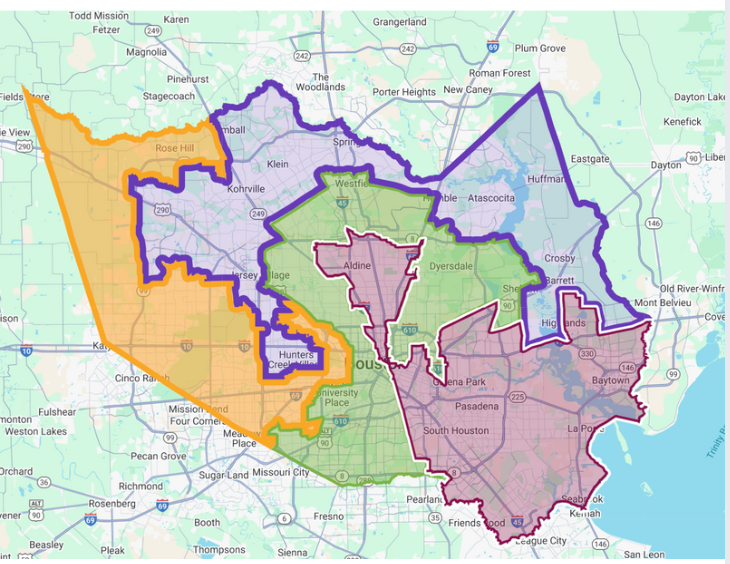
Most organizations operate inside what we call a Civically Fragmented Landscape.
A single neighborhood. A school campus. A management district.
Each one is typically governed by multiple overlapping civic authorities — a city council district, a county precinct, a school district, a state legislative district, a congressional boundary — all cutting across the same geography, each with different priorities, different funding cycles, and different definitions of who is responsible for what.
The result is predictable, and costly. When a community sits at the intersection of multiple boundaries, accountability becomes diffuse. Funding falls into the gaps. And organizations are left navigating a system where it always seems to be someone else's responsibility.
No single office sees the whole community. And no single community has one clear voice.
This is Civic Fragmentation — and it is the invisible force shaping outcomes for nearly every organization we work with.
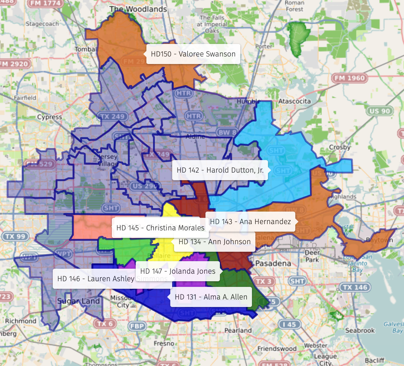
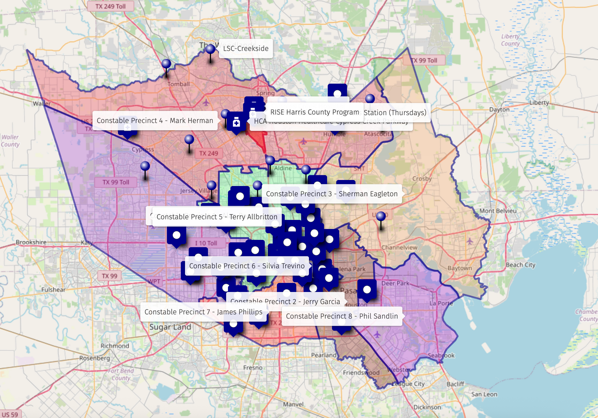
The Civic Layer maps every jurisdiction governing your geography, names the offices and the people within them, and shows exactly how they overlap.
For most organizations, this is the first time they have ever seen that picture assembled in one place. Because you cannot build relationships with a system you cannot see. And you cannot advocate for your community until you understand who actually represents it.
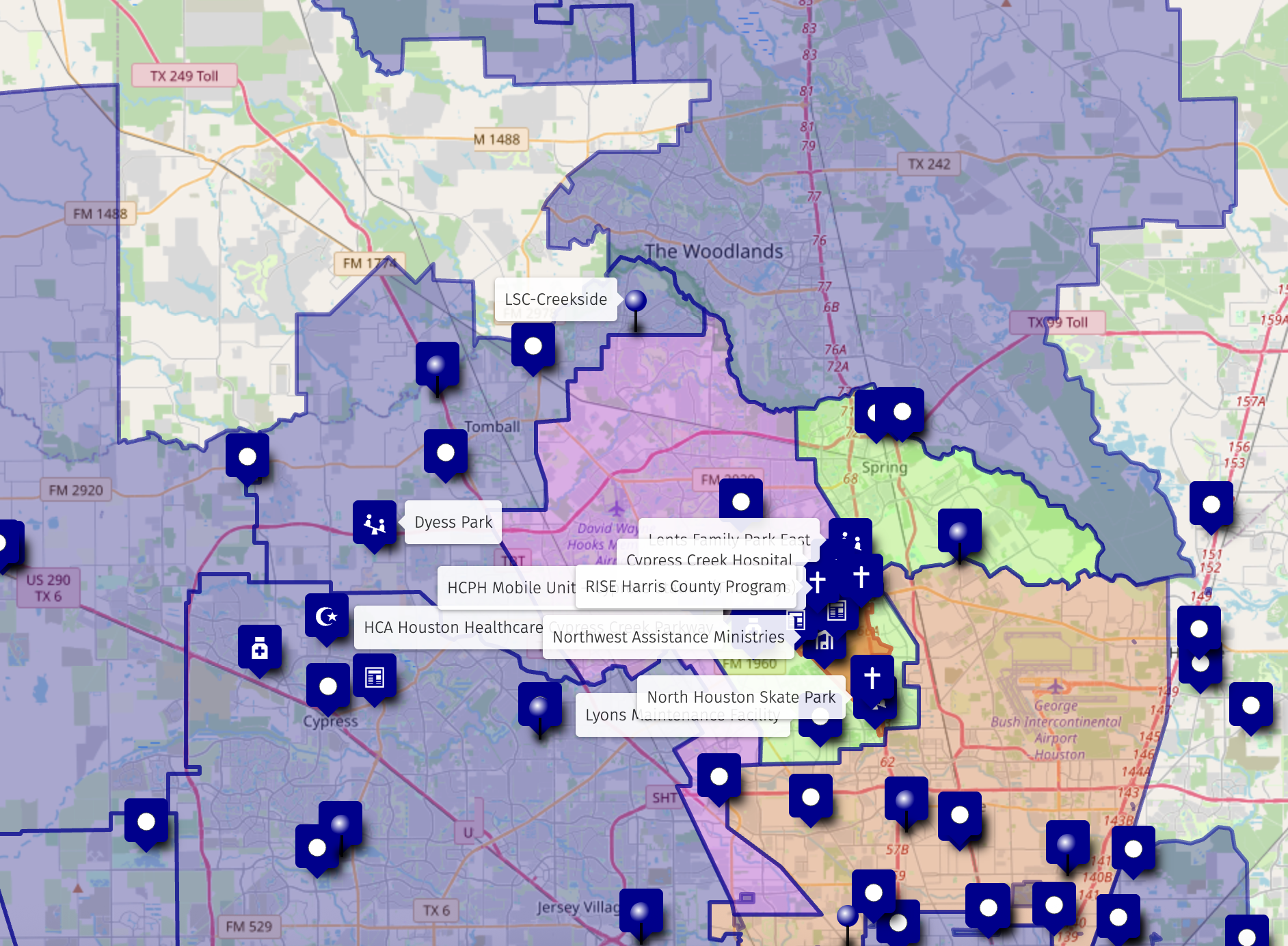
Public Supports
In a civically fragmented landscape, public resources that exist to serve your community are often invisible to the organizations that need them most.
Public funding and services are already in your landscape. Most organizations never know how to reach them.
Greater Houston's civic fragmentation means that a single neighborhood may be served by multiple overlapping public systems — each with its own funding streams, service boundaries, and points of access. Public school districts, county health clinics, library systems, workforce development programs, and public infrastructure investments are already operating in your geography. They are resourced, they are mission-aligned, and they are largely untapped by the nonprofits working alongside them.
The Public Supports View changes that.
This layer maps the government-funded programs, public institutions, and civic resources operating within your landscape — the ISD campuses and district initiatives, Harris County public health clinics, Houston Public Library branches, workforce development programs, and other publicly funded services whose reach overlaps with your own.
We map and highlight these resources so your leadership can see, often for the first time, what public infrastructure already surrounds your work — and where your organization has a legitimate pathway in.
The Public Supports View of your Atlas does not just identify resources — it reveals where civic investment is already flowing in your community. Where a public school district initiative aligns with your programming. Where a library branch serves the same families you do. Where a county health clinic could become a referral partner. Where public funding pathways exist that your organization is positioned to access.
This is some of the highest-leverage work the Atlas delivers. Most organizations walk away from this layer with a funding conversation or a civic relationship they did not know was available to them.
Collaborative Networks
In a civically fragmented landscape, organizations doing powerful, complementary work are often invisible to one another.
Collaboration rarely fails for lack of goodwill. It fails for lack of a shared map.
They serve overlapping populations. They operate in the same geography. They share funders, school campuses, and community relationships. And in most cases, they have never been introduced — not because the will to collaborate is missing, but because no one has ever mapped what surrounds them.
The Collaborative Layer changes that.
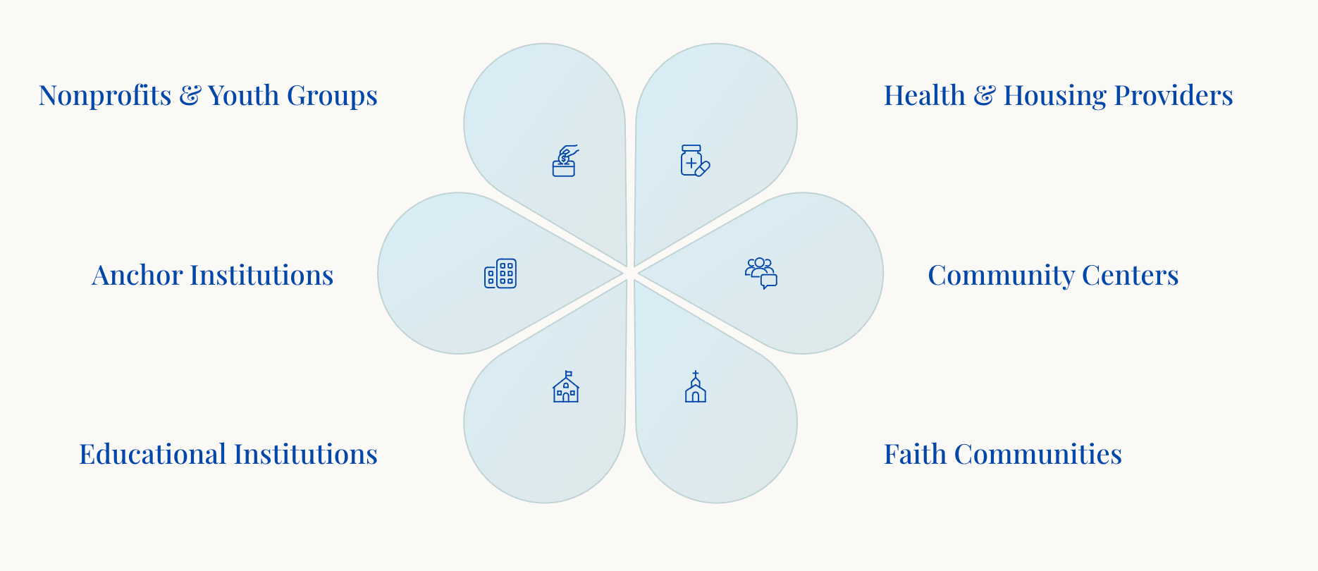
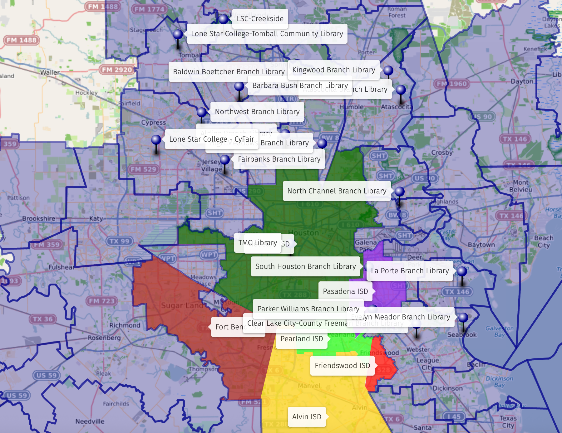
This layer identifies the organizations, institutions, and networks in your community whose work complements, strengthens, or naturally extends yours. These are your potential partners — the nonprofits, public schools, libraries, health providers, faith communities, workforce programs, and civic coalitions already operating in your landscape.
We map and highlight these organizations so your leadership can see, often for the first time, who is already near you, what they do, and where genuine alignment exists. What has been invisible becomes a strategic resource.
The Collaborative View in your Atlas does not just identify partners — it reveals the relational geography of your community. Where shared missions can become shared strategies. Where a simple introduction unlocks a referral pathway. Where two organizations serving the same families can stop duplicating effort and start multiplying impact.
This is one of the most immediate and actionable things the Atlas delivers. Most organizations walk away from this layer with a partnership conversation they can start the following week.
Layer 3
Competitive Awareness
In a civically fragmented landscape, organizations frequently find themselves doing overlapping work without knowing it.
Competitive Awareness is not about rivalry. It is about knowing your place in the ecosystem with enough clarity to stand in it confidently.
Same geography. Same population. Similar mission. Different name on the door. When the ecosystem is invisible, duplication is invisible too, and so are the gaps where real need goes unmet because everyone assumes someone else is covering it.
This Layer Reveals who is doing similar work in your geography, where missions overlap and duplication quietly drains resources, where genuine gaps in service remain, and where your organization is uniquely positioned to fill them, how your work is distinct, and how to say so with precision, and what funders see when they look across the ecosystem — and how to make your role unmistakably clear
This layer is where many organizations have their most clarifying moment.
When you can see the full competitive landscape, you stop describing your work in isolation and start describing your place in the system. That shift changes how funders understand you, how partners engage you, and how your board talks about the mission.
Competitive Awareness is geographic awareness. Where you operate, when you intervene, and who you serve in relation to others — these are not abstract positioning questions. They are answered by the map.
The Competitive View in your Atlas gives your leadership the external view that is nearly impossible to construct from inside your own organization. It is not about proving you are different. It is about seeing, clearly and honestly, exactly where you fit, and making that case with confidence.
The 3-Layer Context Map Framework
One of the most valuable tools we use at Bird's Eye Impact is the 3-Layer Context Map, a framework that helps organizations understand their true position within the community ecosystem. Most teams know their mission and their clients. Some know a handful of partners. But very few can see the full landscape shaping their opportunities, challenges, and growth.
The 3-Layer Context Map makes that landscape visible by bringing together the three layers every organization operates within: Civic, Collaborative, and Competitive Awareness.

Layer 1
Civic Systems
This layer identifies the power structures and public assets that determine access, voice, funding, and opportunity.
We identify and map relevant governmental entities -- local, county, state, and federal -- that offer resources, funding, services, or advocacy opportunities.
This includes elected officials, public departments, and agencies that align with your mission, helping your organization uncover overlooked supports and build relationships.
In many communities we analyze, the civic landscape is highly fragmented — with neighborhoods split across multiple city council districts, county precincts, school districts, state legislative districts, or even overlapping federal boundaries.
This fragmentation often leads to gaps in visibility, inconsistent support, and the sense that no single office feels fully responsible for the area.
By revealing these divides, we help organizations understand why proactive communication with each civic district is essential.
Layer 2
Collaborative Networks
This layer identifies all the potential partners around you -- organizations doing work that complements, strengthens, or expands yours. This surfaces where collaboration is possible and where shared missions can become shared strategies.
We map and highlight organizations, institutions, and networks in your area that could become high-impact partners. These groups might include nonprofits, public schools , public health providers, coalitions, or civic groups whose work complements your own.
In many community-analysis projects, this collaborative mapping reveals a wide spectrum of practical and high-value partnership opportunities.
Layer 3
Competitive Awareness
This layer identifies the organizational "neighbors" in the work -- those offering similar services, targeting similar populations, or operating in the same space.
What This Layer Reveals
- Who is doing similar work
- Where duplication exists
- Where gaps in service remain
- How your organization can differentiate and sharpen its message
This layer isn’t about creating a zero-sum 'advantage' -- it’s about mapping your place in the community to give you the awareness needed to clarify your distinct value.
With this insight, you can refine your messaging, avoid overlap or confusion, and present a sharper, more compelling case to funders, partners, and community stakeholders.
Civic Landscaping delivers a Bird's Eye View.
When your organization can see the civic systems that govern your geography, the public supports that have the ability to further your programs, the collaborative opportunities hiding in plain sight, and the competitive landscape that defines your place in the ecosystem, everything shifts.
You stop navigating blind. You start moving with clarity.
The
Bird's Eye Interactive Map is the tool that makes this possible. And the
Bird's Eye Atlas is how it reaches your hands, a complete, ready-to-use intelligence package that gives your leadership the full picture of the landscape surrounding your work.
The civic landscape around your organization already exists. The funding is there. The partners are there. The relationships that could change your trajectory are there.
Civic Landscaping makes them visible. The Atlas makes them actionable
Civic Engagement
Know exactly which civic offices to engage and how their priorities align with your mission
Strategic Partnerships
Identify which partners to build alignment with for maximum collaborative impact
Differentiation
Understand how to stand out in a complex ecosystem while avoiding duplication
Strategic Opportunities
See where the true leverage points lie within your community landscape
1 - Civic Supports
We identify and map relevant governmental entities—local, county, state, and federal—that offer resources, funding, services, or advocacy opportunities. This includes elected officials, public departments, and agencies that align with your mission, helping your organization uncover overlooked supports and build relationships.
In many communities we analyze, the civic landscape is highly fragmented — with neighborhoods split across multiple city council districts, county precincts, school districts, state legislative districts, or even overlapping federal boundaries.
This fragmentation often leads to gaps in visibility, inconsistent support, and the sense that no single office feels fully responsible for the area. Our mapping brings this complexity to the surface, showing where responsibility is diffuse and where important districts may be unaware of the community’s needs.
By revealing these divides, we help organizations understand why proactive communication with each civic district is essential: when a community sits at the edge of multiple boundaries, it is often unintentionally overlooked. Our approach equips you to build consistent relationships across all relevant offices so your mission remains visible, supported, and understood.
2 - Collaborative Opportunities
We map and highlight organizations, institutions, and networks in your area that could become high-impact partners. These groups might include nonprofits, public schools , public health providers, coalitions, or civic groups whose work complements your own.
In many community-analysis projects, this collaborative mapping reveals a wide spectrum of practical and high-value partnership opportunities.
For example, literacy-focused initiatives often emerge across multiple sectors — from public library systems (including mobile library units) and community literacy nonprofits, to school-based programs and family resource centers. We frequently identify adjacent partners whose missions support overall community well-being, such as local assistance ministries, youth development organizations, public health providers, and homelessness response agencies.
By visualizing these networks together, we help clients see where natural alliances already exist, where complementary programs can reinforce their mission, and where targeted introductions could unlock shared resources or coordinated service delivery.
3 - Competitive Awareness
Understanding your competitive environment is essential for clear and effective positioning. We identify organizations and programs that serve similar constituents or operate in the same issue space, mapping their locations, understanding how they present themselves, identifying services they offer, and observing where they are most visible.
This layer isn’t about creating a zero-sum 'advantage' — it’s about giving you the awareness needed to clarify your distinct value. With this insight, you can refine your messaging, avoid overlap or confusion, and present a sharper, more compelling case to funders, partners, and community stakeholders.
From Insight to Impact: The Bird's Eye Atlas
Once we map your organization within the broader civic, collaborative, and competitive landscape, we help you turn that perspective into action with the Bird's Eye Atlas.

The Bird’s Eye Atlas is a complete suite of insights and tools -- combining data, maps, and narrative to give organizations a clear, actionable view of their community.
The Atlas includes a Baseline Analysis, Civic & Collaborative Map, Executive Summary & Program Recommendations, The Advocacy Book, and a Stakeholder Presentation — together forming a comprehensive reference for strategy, collaboration, and advocacy.
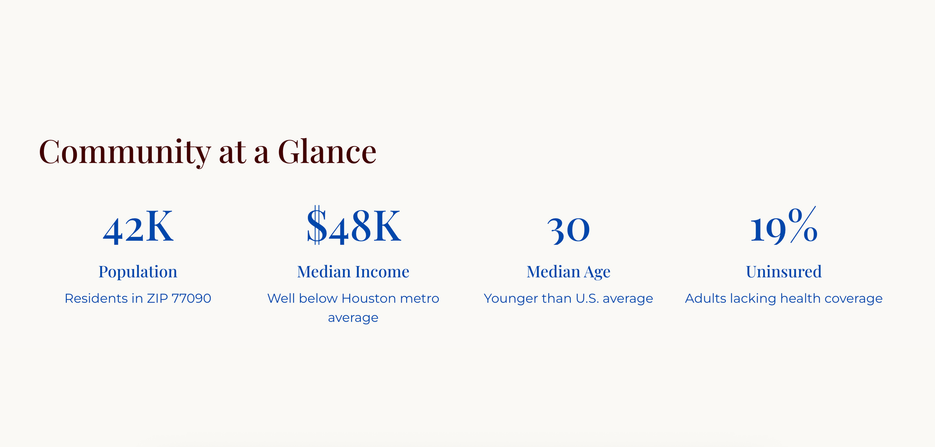
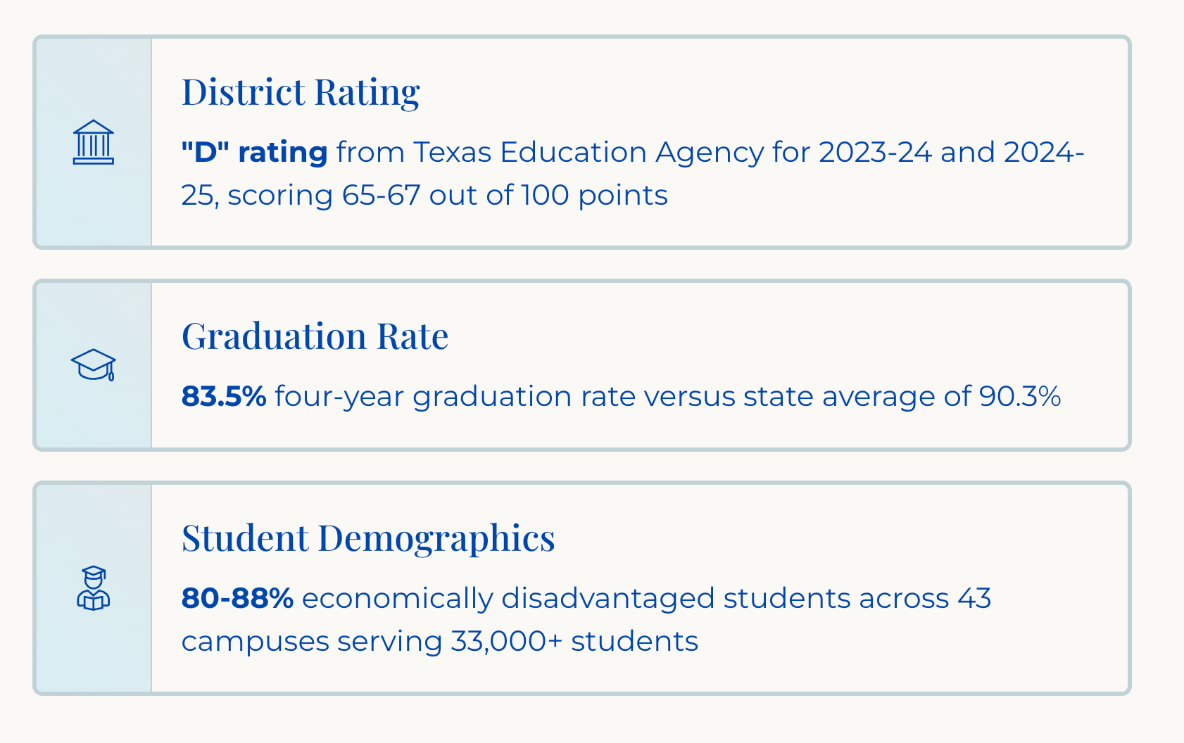
Resource 1: Baseline Community Analysis and Socio-Economic Context
We provide a detailed demographic overview and data-driven analysis of your operating landscape. This includes crucial socio-economic indicators such as population size, median household income, median age, educational attainment rates, housing composition (e.g., high rental density), and challenges like the percentage of uninsured residents.
Our analysis identifies core challenges in the community, such as educational attainment gaps, housing vulnerability, crime rates, and limited mobility, which constrain resources and opportunity.
Resource 2: Civic and Collaborative Map
This deliverable visually maps the geography of opportunity and challenge. The map includes the area's Civic Supports (local, county, state, and federal jurisdictions) and identifies Collaborative Opportunities (partnerships with schools, libraries, parks, community centers, health providers, and faith-based organizations).
This mapping addresses the jurisdictional challenges often faced by communities, such as fragmented services and coordination gaps.
Resource 3: The Advocacy Reference Book
This resource serves as a centralized guide to relevant civic and collaborative resources. It includes key contacts and outlines resources necessary for advocacy, leveraging the information gathered through our Civic Supports and Collaborative Opportunities mapping.
This book is a tool to help transform civic fragmentation into collaborative momentum.

Resource 4: Executive Summary and Program Recommendations
We provide an Executive Summary of the analysis outlining the strategic findings and our recommendations for action. Recommendations are focused on coordinated local initiatives designed for long-term outcomes.
This mapping addresses the jurisdictional challenges often faced by communities, such as fragmented services and coordination gaps.
Resource 5: Refined Stakeholder Presentation
A polished, presentation-ready version of the analysis, recommendations, and strategic plan, suitable for delivery to stakeholders, board members, funders, and community members.
This presentation helps your organization advocate for community needs and demonstrates measurable progress. It communicates how strategic investment delivers exponential returns compared to crisis intervention.

Our Signature Approach:
The
3-Layer
Map Context
Bird's Eye Impact delivers tailored geographic and organizational analysis using a three-part mapping method:
1. Civic Supports
We identify and map relevant governmental entities—local, county, state, and federal—that offer resources, funding, services, or advocacy opportunities.
This includes elected officials, public departments, and agencies that align with your mission. By visualizing these connections, we help your organization uncover overlooked supports and build relationships that can unlock new opportunities for growth, influence, and sustainability.
2. Collaborative Supports
We map and highlight organizations, institutions, and networks in your area that could become high-impact partners. These might include nonprofits, schools, health providers, coalitions, or civic groups whose work complements your own.
By identifying where missions align or audiences overlap, we help you strategically engage collaborators who can expand your reach, share resources, and strengthen program delivery.
3. Competitive Sets
Understanding your competitive landscape is key to strategic positioning. Bird’s Eye Impact maps organizations with similar missions or services in your area, helping you assess their visibility, funding sources, and programming focus. This insight allows you to clearly define what makes your work distinctive—so you can differentiate your brand, make a stronger case to funders, and sharpen your messaging.